In situ Data and Services Center Shom

Le Shom, héritier du premier service hydrographique officiel au monde (1720), est un établissement public administratif (EPA) sous la tutelle du ministère des Armées. Il est l'opérateur public pour l'information géographique maritime et littorale de référence.
Il a pour mission de connaître et décrire l’environnement physique marin dans ses relations avec l’atmosphère, avec les fonds marins et les zones littorales, d’en prévoir l’évolution et d’assurer la diffusion des informations correspondantes. Plus d’informations sur les missions du Shom. Ses domaines d’expertises sont la bathymétrie, l’océanographie, la géophysique marine, l’observation du niveau de la mer, la sédimentologie marine, l’acoustique sous-marine, la physique de la mesure et techniques d’observations, l’information géographique maritime et littorale.
Pour remplir ses missions, le Shom intervient depuis l’acquisition des données en passant par leur exploitation adaptée aux différents besoins, et jusqu’à la diffusion des produits réalisés. Ces activités reposent sur de fortes compétences en matière de préparation des systèmes d’observation, de qualification et de traitement des données, d’élaboration et de diffusion de produits et services
Le Shom gère des données issues de deux composantes :
- Observation du niveau de la mer
L’observation du niveau de la mer fait partie des activités historiques menées par le Shom et constitue encore aujourd’hui un domaine d’expertises technique et scientifique. Elle intervient dans la conception de plusieurs produits du Shom tels que les cartes de navigation, les prédictions de marée ou les niveaux caractéristiques de la marée et sert de nombreuses applications : hydrographie, études des surcotes et niveaux extrêmes, préventions des risques et étude du niveau moyen de la mer.
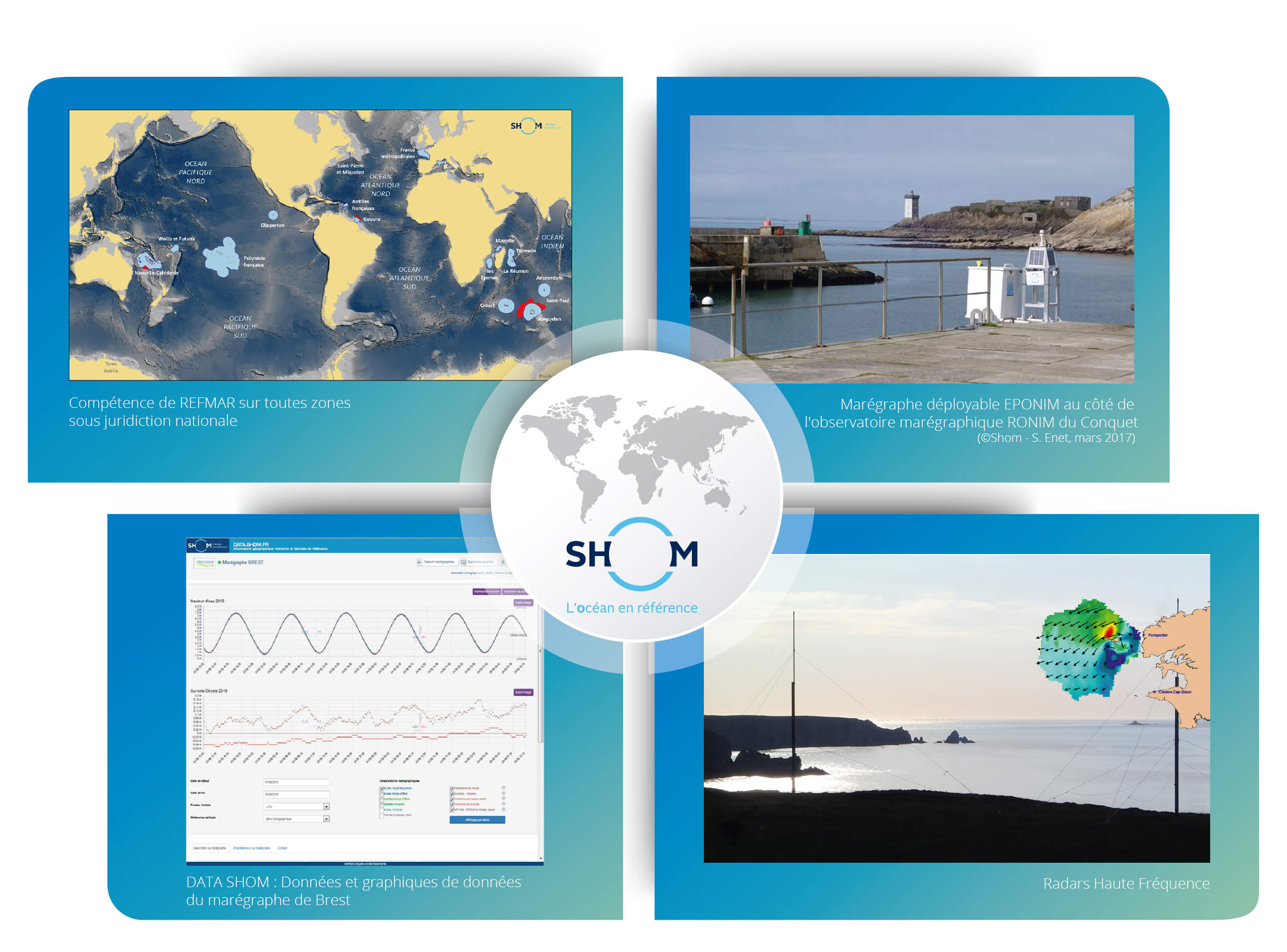
Le Shom est le référent national pour l’observation in situ du niveau de la mer et assure ces fonctions sous l’acronyme REFMAR. Ce rôle est coordonné par le Shom et est sous pilotage du Secrétariat général de la mer (SGmer) ; il reçoit le soutien de plusieurs ministères (ministère de la transition écologique, ministère de l'intérieur et ministère des armées).
REFMAR coordonne aujourd’hui 142 stations marégraphiques françaises dont ceux du réseau RONIM (Réseau d’Observation du NIveau de la Mer géré par le Shom, actuellement composé de 50 dispositifs situés en Métropole (40) et en territoires d’outre-mer), ROSAME et ceux d’une vingtaine d’autres partenaires fin 2022.
Les observations sont mises à disposition gratuitement sur le portail de l’information géographique maritime et littorale de référence du Shom, https://data.shom.fr.
- Observation des courants de surface
Entre 2006 et 2021, le Shom a exploité un radar haute fréquence (HF) en Mer d’Iroise, permettant la mesure du courant de surface. Depuis 2022, le Shom et Ifremer en assurent conjointement l’exploitation.
Jeux de données publiés et mis à jour récemment
Nom | Brève description | |
RONIM | Données d’observations du niveau de lamer collectées par les marégraphes du réseau RONIM. | http://dx.doi.org/10.17183/REFMAR#RONIM |
Données d’observations du niveau de lamer collectées par les marégraphes des partenaires REFMAR. | http://dx.doi.org/10.17183/REFMAR#PARTENAIRES | |
Nouvel observatoire « Ua Pou » du niveau de la mer (Marquises – PF). Partenaires : UPF, DPAM, Shom. | DOI du marégraphe : 10.17183/REFMAR#262
| |
Nouvel observatoire « Lorient » du niveau de la mer (Morbihan (56)). Partenaire : région Bretagne. | ||
Nouvel observatoire « Fromentine » du niveau de la mer (Vendée (85)). Partenaire : Communauté de commune Océan-Marais de Mont | DOI du marégraphe : 10.17183/REFMAR#186
|
In-situ
- HF Radar
- Tide gauges
- CPER Bretagne 2021-2027 : Projet ROEC-ILICO « Réseau d’Observations pour l’Environnement Côtier de l’Infrastructure LIttorale COtière » du méta-projet ObsOCéan « Observations et systèmes d’observation de l‘Océan ». Actions pour maintenir et consolider le réseau d’observation côtier du niveau de la mer, en Bretagne.
- DataRescue : Valorisation des observations « archéologiques » de niveaux d’eau: poursuite des actions permettant de valoriser son patrimoine historique depuis quelques années déjà. Cette initiative s'établit dans le cadre des activités REFMAR et SONEL et s’intègre dans une démarche actuelle plus internationale et répond aux recommandations du programme Global Sea Level Observing System (GLOSS) piloté par la Commission Océanographique Intergouvernementale (COI/UNESCO) sur la valorisation des observations « archéologiques » de niveaux d’eau.
- Reconstruction de séries marégraphiques : En 2022, la reconstruction de la série marégraphique de Saint Malo a été finalisée et un nouveau projet portant sur la reconstruction des séries de trois sites dans l’estuaire de la Gironde a été initiée.

Pour la gestion du réseau RONIM, le Shom propose un outil de supervision permettant de suivre en temps réel l’état des 50 stations marégraphiques du réseau et de réaliser des opérations de maintenance à distance (mise à jour, redémarrage, …). Cet outil permet également la collecte des données permettant de peupler le portail de diffusion data.shom.fr
| Website | Link / Contact |
|---|---|
| Shom | shom.fr |
| Maritime and coastal geographical information portal (Data Shom) | data.shom.fr |
| REFMAR | refmar.shom.fr |
| SONEL | sonel.org |